See it and immediately know
Every screen tells its viewer the state at a glance: which segments are smooth, slowing or unmanaged, where the hot spots are, which evidence is ready and which is missing.

Public road traffic operations, safety and funding
Municipath is the operations app for a road corridor. It plans, checks, coordinates, records and reports, for the cities, counties, regions, toll authorities and state DOT districts that each hold a piece of the same road. Every claim on a screen is backed by a record: its data, its source, its date.
Open the proof of concept Watch the films
A proof of concept. Demo organizations, not affiliated with any agency. Operating values are illustrative.
What it is
Traffic on a corridor like I-4 is decided car by car, by drivers reacting to each other with almost no information. Phantom slowdowns, crashes and secondary crashes follow. The state holds the highway data, the toll authorities hold the tag reads, the regions hold the plans and the cities run the signals. Nobody joins them.
Every screen tells its viewer the state at a glance: which segments are smooth, slowing or unmanaged, where the hot spots are, which evidence is ready and which is missing.
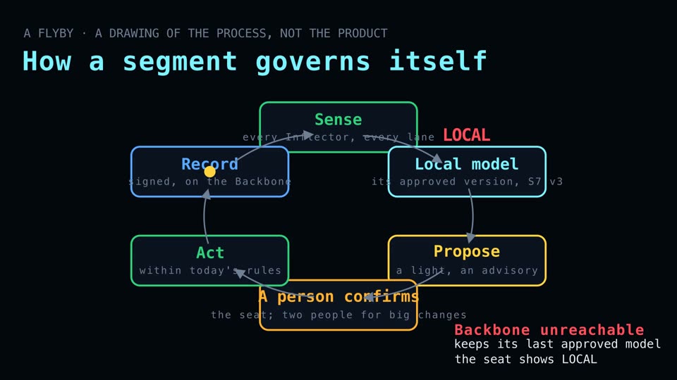
The system may lower a section's speed, close or shift a lane, or hold a merge. It never commands a vehicle to accelerate or steer. A failed section falls back to its posted limit and shows as unmanaged.
It detects stopped, wrong-way, weaving or dangerously slow vehicles and protects everyone else upstream. A live track goes to law enforcement. It never orders a stop: that is police power.
Road units report passages, not identities. The twin reasons about sections of road. People are not its subject.
Every figure in a grant package, a report or a screen carries its data, its source and its date. Anything modelled is labelled as modelled and never shown as a recording.
A tenant's users see their own organization's product in their own look. What a status means never changes with the brand: the road's own MUTCD colours and shapes, always with a word.
Awareness, fit, submission, visibility, delivery and reporting run through the product. Every operational screen shows which funding criteria its data supports and which report it feeds.
A state is set up once, with its data sources, statutes and safety plan, and every release is tagged. Regions and cities move to a new version on purpose, on the record.
Now showing
The narrated programs run inside the proof of concept, on its own screens, with a presenter and recorded voice. The Flybys below are drawings of a process, made for the Inflector program. They are picture only: the broadcast speaks over them.
Try it
Corridor Now, the Flythrough, the Snake, Incident, Drone Stations, Hot Spots, the Funding Radar and the rest, set on I-4 from Tampa to Daytona Beach. It runs in your browser with nothing to install. Switch the demo organization, the scheme and light or dark mode from the rail.
Demo organizations, not affiliated with any agency. Values illustrative. Designs are labelled as designs. It is a large page and takes a moment to open.
 Open the POC